PXLWRKR
← Back to all projects

Real-Time Location Product for Enterprise Field Operations

ArcGIS Tracker (Track Viewer) · Esri

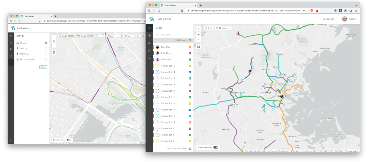
ArcGIS Track Viewer — hero
ArcGIS Track Viewer — hero detail
Role
Product Designer (sole web designer)
Scope
Track Viewer web app, administrator workflows, configure-on-web product direction
Team
Product Owner, Product Designer, Developers (5), Quality Assurance
Timeline
2018 – 2020
Status
Public, shipped

The work

ArcGIS Tracker was Esri's real-time location product — a paired web-and-mobile solution that let organizations record where their field personnel were and analyze where they'd been. The web app, Track Viewer, was the administrator's surface: define who gets tracked, who can view those tracks, and how the tracking is set up across teams. The mobile app was the field side — the device in the supervisor's hand, recording location and feeding it back to the platform in real time. The product existed for two reasons that mattered equally. One, the platform had new real-time location services that needed a flagship product to showcase them. Two, mobile devices had recently gained a class of sensor capability — heart rate, accelerometer, fall detection — that opened design space that hadn't existed on previous Esri products.

The work was hard because of where it started and where it had to end up. The team's initial research direction was first-responders — police, fire, EMS — and the design hypothesis was that the accelerometer and heart-rate sensors in modern phones could detect crashes, falls, and other high-risk events and surface them to operators on the Track Viewer dashboard in real time. The technology worked. The customer interest was real. And partway through development, legal review came back with a determination that the liability exposure of shipping crash-detection and incident-detection features for first-responder use was too high for Esri to absorb. The product couldn't ship the feature set the team had spent months designing for. The question wasn't whether to redirect — that was decided for us — it was what the product became instead, and how much of the work survived the pivot. On top of that, the platform-services architecture meant Tracker's underlying real-time location services were being designed for reuse across other ArcGIS products from the start; the scope of Track Viewer itself had to stay deliberately narrow so the services it consumed could be general enough to feed adjacent products later.

I was the sole web designer on Track Viewer, partnered across teams with the mobile designer on the Tracker mobile team who owned the field-side experience. The Tracker product was two teams shipping in parallel — the Track Viewer web team I sat on, and the Tracker mobile team building the device-side app — coordinating through the product managers, the engineering leads, and a direct working relationship between the two designers. My remit was the entire web product — administrator workflows, view configuration, the analyze-where-they've-been surfaces — and the configure-on-web side of the configure-on-web / consume-on-mobile model the Field Apps line was built around. The configuration decisions I made on the web directly shaped what the field user saw on the mobile device, which made the cross-team design partnership a structural requirement of the product, not an optional collaboration.

Approach and decisions

01

Designing for first-responders, and absorbing the pivot when it came

The first phase of Track Viewer research focused on first-responder workflows. We interviewed police departments, fire crews, and EMS dispatchers, and the design hypothesis the team rallied around was high-stakes incident detection — using the sensors in modern mobile devices to identify crashes, falls, and abnormal vital signs in the field, and surface them to operators on the web dashboard in real time. The web design started consolidating around an operator console pattern: a live map of personnel locations, an alert lane that surfaced sensor-triggered events as they happened, and the workflows for the operator to acknowledge, route, and resolve those events. Months of work were oriented around that direction.

When legal review came back with the determination that crash-detection and incident-detection features carried liability exposure Esri couldn't absorb for first-responder customers, the product had to redirect. The sensor-driven alert surfaces, the operator-console framing, and the first-responder-specific workflows all came out of scope. What we were left with was the underlying platform capability — real-time location of personnel, configurable views, historical track analysis — but no longer the flagship use case the design had been built around.

The design work the pivot required wasn't a rewrite from zero. It was a careful audit of which decisions had been first-responder-specific and which had been general enough to survive into a broader product. The operator-console framing went. The alert lane went. The sensor-trigger surfaces went. What stayed was the administrator's mental model — who is tracked, who can view, what time windows are visible — which turned out to be the actually durable part of the product. Track Viewer shipped as a more general real-time location product, used by utilities, transportation, government inspection programs, and field service organizations whose tracking needs didn't carry the same liability profile. The pivot worked because the team had been disciplined about separating the configurable foundation from the use-case-specific surface; what we lost was real, but it was the top layer, not the whole stack.

The lesson the project taught me about this kind of redirect — the kind where a constraint outside the team's control reshapes the work — is that the question isn't whether to grieve the lost direction. It's how quickly you can identify what survived, and how confidently you can rebuild the narrative around it. The team that gets stuck on the lost direction loses months. The team that finds the durable layer underneath ships.

02

Keeping Track Viewer narrow so the services could go wide

The architectural decision that shaped Track Viewer most, beyond the pivot, was one the team made deliberately before the pivot ever happened: keep the product scope narrow on purpose so the platform services underneath it could be general. The real-time location services Tracker was built on were being designed for reuse across the ArcGIS platform — Workforce was going to consume them, Field Maps was going to consume them when it eventually absorbed Tracker's capabilities, and other products downstream were going to consume them in ways the team couldn't fully anticipate yet. If Track Viewer's design pulled too hard on the services to fit Track Viewer's specific needs, those services would become Track-Viewer-shaped and harder to reuse. If the design stayed within what the services could offer as a general capability, the services stayed general.

That constraint translated into specific design decisions in the web product. I held the line against feature requests that would have required service extensions specific to Track Viewer's UI — custom aggregation, custom time-window logic, custom event types — and pushed those decisions into the configure-on-web surfaces where the administrator could compose general capabilities into specific outcomes for their organization. The web app didn't tell the services what to do; it told the administrator how to express what they wanted within what the services already supported. That's a less interesting product story from a screenshot perspective, but it was the right one for the platform.

The payoff arrived later, in two places. Field Maps consumed Tracker's services when it absorbed the tracking capability into the unified field-data product — the services were already general enough to slot in without rework. And other ArcGIS products that needed real-time location functionality picked up the services without having to negotiate around Track-Viewer-specific assumptions baked into them. The Track Viewer team's discipline about scope is invisible in the shipped Track Viewer product, but it's why the platform got real-time location infrastructure that survived the product itself.

03

Configure-on-web, consume-on-mobile across two teams

Track Viewer and the Tracker mobile app were two surfaces of one product, built by two teams. The Track Viewer web team I sat on owned the administrator experience; the Tracker mobile team owned the field user's device experience. The design relationship between the two surfaces had to be designed as deliberately as either surface on its own — and it had to be designed across an org boundary, not within one. The administrator built a track view on the web, defined who was tracked, what time windows were visible, what permissions applied to which viewers — and the field user's mobile experience was a direct consequence of those configuration decisions. A web decision that didn't account for what the mobile user would experience created a broken handoff; a mobile design that didn't account for what the web could actually configure created a feature the administrator couldn't deliver. The two teams shipping independently was a structural risk to the product, not a neutral org fact.

I built a direct working relationship with the mobile designer on the Tracker mobile team and ran standing design reviews where both surfaces were on the table at once — not "I'll show you the web, then you show me the mobile," but "here's the workflow end to end, and here's where the seam between the two surfaces is sitting." Those reviews ran outside the formal cross-team coordination the product managers and engineering leads were doing; they were a designer-to-designer working forum that existed because the product needed it. The decisions that came out of those reviews were rarely about either surface in isolation; they were about where the seam belonged. When the administrator turned tracking on for a group, what did the field user see on their device? When the administrator changed the time-window policy mid-shift, what state did the mobile app land in? Those seams were the actual product, and getting them right across two teams meant the two designers treated the work as one deliverable even when the teams shipping it didn't.

That cross-team paired-design model is what I carried forward into Field Maps when the products consolidated. The configure-on-web / consume-on-mobile workflow Field Maps inherited from the Field Apps line wasn't an architecture diagram I learned on Field Maps — it was a working practice I'd already developed across the Tracker team boundary, ready to apply at higher scale on the consolidated product, where the web and mobile work eventually came together on a single team.

Outcomes

Track Viewer shipped, took its place in the ArcGIS Field Apps line, and ran in production until its tracking capabilities were absorbed into ArcGIS Field Maps as part of the broader Field Apps consolidation. What can be named:

  • Track Viewer shipped as the web administrator surface for ArcGIS Tracker, with the configure-on-web / consume-on-mobile model fully realized across the paired product.
  • The product survived a mid-development pivot away from its founding use case — first-responder crash and incident detection — without the loss of months of design work, because the configurable foundation had been built generally enough to survive the change.
  • The underlying real-time location services were adopted by adjacent ArcGIS products, including Field Maps when it absorbed Tracker's capabilities into the unified field-data product. The discipline of keeping Track Viewer's scope narrow paid off as platform infrastructure, not just as a single product.
  • The cross-team paired-design model became the template for how I approached the configure-on-web / consume-on-mobile boundary on subsequent Field Apps products — a designer-to-designer working forum that ran alongside the formal cross-team coordination, ready to apply at higher scale when Field Maps consolidated the web and mobile work onto one team.

Reflection

The project taught me what to do when a constraint outside the team's control invalidates a direction the team has already committed to. The instinct — mine, and most teams' — is to argue the constraint, then negotiate the constraint, then mourn what was lost when the constraint holds. The thing I learned on Tracker is that all three of those moves cost time the project doesn't have, and the move that actually matters is the fourth one: separate what was use-case-specific from what was foundational, throw out the first cleanly, and rebuild the narrative around the second before the team loses the months it just spent.

I've used that move twice since, in different contexts — once when a security review reshaped a feature set late, once when a partner integration fell through the floor. Both times the team got there faster because Tracker had already taught me what the question to ask was. Not "what do we save," but "what was always going to survive this, and how do we make that obvious to everyone in the room by the end of the week."

Artifacts